Rift Valley Province
| Rift Valley Province | |
|---|---|
| — Province — | |
 |
|
 |
|
| Coordinates: | |
| Country | |
| No. of districts: | 36 |
| Capital | Nakuru |
| Area | |
| - Total | 182,413 km2 (70,430.1 sq mi) |
| Population (2007) | |
| - Total | 8,786,300 |
| Time zone | EAT (UTC+3) |
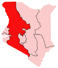
Rift Valley Province of Kenya, bordering Uganda, is one of Kenya's seven administrative provinces outside Nairobi. Rift Valley Province is the largest and one of the most economically important provinces in Kenya. It is dominated by the Great Rift Valley which passes through it and gives the province its name. According to the 1999 Census, the province covers an area of 173,854 square kilometres (42,960,000 acres; 67,125 sq mi) and has a population of 8,786,300 inhabitants (2007), making it the largest and most populous province in the country. The capital is the town of Nakuru.
Contents |
Geography
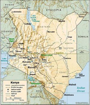
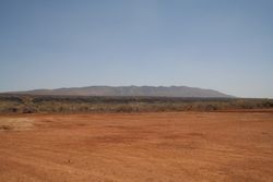
The Great Rift Valley runs south through Kenya from Lake Turkana in the north and has several unique geographical features, including the Elgeyo escarpment which is a popular tourist attraction.
Apart from the Rift Valley itself, the area has other important geographic features such as: the extinct volcanoes Mount Longonot and Mount Suswa and Lake Baringo, Lake Bogoria, Lake Magadi, Lake Nakuru, Lake Naivasha, the Suguta Valley, and Lake Turkana.
Economy
The highlands provide adequate rainfall for farming and agriculture which is the economic base of the residents of the Rift Valley. Tea from the highlands in the Kericho district enjoy a world wide reputation, but horticulture is an important part of the district's economy and cattle raising is also practised to a large extent.
The full economic potential of the Rift Valley region is, however, far from fully exploited and the current growth in population and improved education will hopefully change this in a near future. People in the province are still mostly rural, but urbanisation is gradually increasing; new cities and towns contain the rural-urban migration and, provided the right policies are instituted, the Rift Valley province will be able to emerge as a national economic and cultural hub.
Ethnicity
The people of the Rift Valley are a mesh work of different tribal identities, and the Kalenjin and the Maasai are two of the best known ethnic groups. Most of Kenya's top runners comes from the Kalenjin community. The Maasai people have the most recognizable cultural identity, both nationally and internationally, and serve as Kenya's international cultural symbol.
Districts
District (capital):
Baringo (Kabarnet) · Bomet (Bomet) · Buret (Litein) · Kajiado (Kajiado) · Keiyo (Iten / Tambach) · Kericho (Kericho) · Koibatek (Eldama Ravine) · Laikipia (Nanyuki) · Marakwet Kapsowar) · Nakuru (Nakuru) · Nandi (Kapsabet) · Narok (Narok) · Samburu (Maralal) · Trans Mara (Kilgoris) · Trans-Nzoia (Kitale) · Turkana (Lodwar) · Uasin Gishu (Eldoret) · West Pokot (Kapenguria)
Districts after 2007
Several new districts have been created since 2007 in Kenya, also in Rift Valley Province [1]:
| District | Capital |
|---|---|
| Baringo Central | Kabarnet |
| Baringo North | Kabartonjo |
| Belgut | Sosiot |
| Bomet | Bomet |
| Buret | Litein |
| Chepalungu | Sigor |
| East Pokot | Chemolingot |
| Kajiado | Kajiado |
| Kajiado North | Ngong |
| Keiyo South | Chepkorio |
| Keiyo | Iten |
| Kericho | Kericho |
| Kipkelion | Kipkelion |
| Koibatek | Eldama Ravine |
| Konoin | Mogogosiek |
| Kuresoi | Keringet |
| Kwanza | Endebess |
| Laikipia Central | Sweetwaters |
| Laikipia East | Nanyuki |
| Laikipia North | Mukogodo |
| Laikipia West | Rumuruti |
| Loitokitok | Loitokitok |
| Loima | Lorugum |
| Marakwet East | Tot |
| Marakwet West | Kapsowar |
| Marigat | Marigat |
| Mogotio | Mogotio |
| Molo | Molo |
| Naivasha | Naivasha |
| Nakuru | Nakuru |
| Nakuru North (Subukia) | Bahati |
| Nandi Central | Kapsabet |
| Nandi East | Nandi Hills |
| Nandi North | Kabiyet |
| Nandi South | Kobujoi |
| Narok North | Narok |
| Narok South | Ololulunga |
| Njoro | Njoro |
| North Pokot | Alale |
| Nyahururu | Nyahururu |
| Pokot Central | Sighor |
| Rongai | Rongai |
| Samburu Central | Mararal |
| Samburu East | Wamba |
| Samburu North | Baragoi |
| Sotik | Sotik |
| Tinderet | Maraba |
| Trans Mara East | Murkhan |
| Trans Mara West | Kilgoris |
| Trans-Nzoia East | Maili Saba |
| Trans-Nzoia West | Kitale |
| Turkana Central | Lodwar |
| Turkana East | Lokori |
| Turkana North | Lokitaung |
| Turkana South | Lokichar |
| Turkana West | Kakuma |
| Uasin Gishu North (Eldoret West) | Eldoret |
| Uasin Gishu South (Eldoret East) | Naiberi |
| Wareng | Outspan |
| West Pokot | Kapenguria |
See also
- Kerio River
|
|||||||||||